Coevorden’s origins lie with a fordable part of the river that was used as a cattle crossing (the Dutch word for cow being koe). This area had developed due to sand and slit deposits and was called a voorde. As time progressed, the area started to be called Koevorde. This ultimately became Coevorden. The name is similar to the English Oxford, which has a similar meaning.
Walking through Coevorden takes you through a medieval city with a special historic past. Its strategic position made the medieval city of Coevorden a vital access point towards the north of the Netherlands. Hostile oppressors were always lurking. This forced Coevorden to take defensive measures; the castle and the remains of its fortifications bear witness to this fact.
In addition to bo…
Coevorden’s origins lie with a fordable part of the river that was used as a cattle crossing (the Dutch word for cow being koe). This area had developed due to sand and slit deposits and was called a voorde. As time progressed, the area started to be called Koevorde. This ultimately became Coevorden. The name is similar to the English Oxford, which has a similar meaning.
Walking through Coevorden takes you through a medieval city with a special historic past. Its strategic position made the medieval city of Coevorden a vital access point towards the north of the Netherlands. Hostile oppressors were always lurking. This forced Coevorden to take defensive measures; the castle and the remains of its fortifications bear witness to this fact.
In addition to boasting a rich history, the atmosphere in Coevorden is convivial and full of charm—something which can be experienced on one of the many terraces in its city centre.
The route starts at Het Arsenaal at Haven 4. It is not signposted. Het Arsenaal houses the Tourist Info office, where you can obtain a route brochure with a map. Free parking is available at car park De Pampert. Located next to swimming pool De Swaneburg (Pampert 2), this car park is only a few minutes’ walk from the centre.
Locations on this route
1
2
3
4
5
6
7
8
9
10
11
12
13
14
15
Directions
1
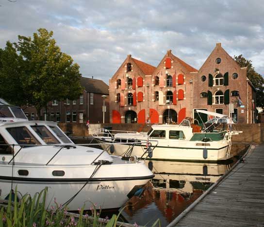
Het Arsenaal was built in the 17th century and was used as a storage location for ammunition, weapons and foodstuffs. Het Arsenaal was behind Bastion Holland, one of Coevorden’s post-war new urban areas. After its restoration in 1970, the building was put into use as a public reading room and library. Het Arsenaal is also where Stedelijk Museum Coevorden and the Tourist Info office are housed. From Het Arsenaal, take a right. On your left lie the remains of the citadel canal, which later became Oude Haven.
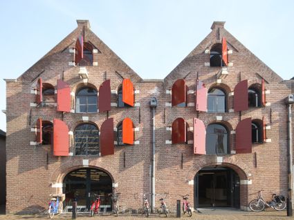
Completed in 2008, the George Vancouver drawbridge is roughly where the original entrance to the castle used to be located. George Vancouver was in the service of the British navy. He mapped out the west coast of the United States and Canada. The city of Vancouver was named after him. George was a distant descendent of the lords of Coevorden. The bridge was given its name in 2010 on account of the Winter Olympic Games. To the right opposite the bridge lies the former warehouse De Vlijt from 1912. Before the bridge on the harbour side, you find...
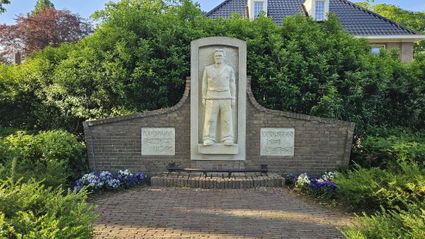
The bust of General J.B. van Heutsz. Van Heutsz gained notoriety following his military activities in Atjeh in the Dutch Indies, where he was posted 1874 until 1897. About twenty metres after having passed the bridge, on your left lies...
The old post office that went into use on 1 April 1892 as a post and telegraph office. Its design is in the famous post office style of government architect C.H. Peters. At the time, a lot of resistance had to be overcome before construction could commence—mainly because the citizenry considered its location “outside of the city.” The building was in use until 1967. On the right street corner, next to the old post office, are a number of characteristic Jugendstil buildings; among them...
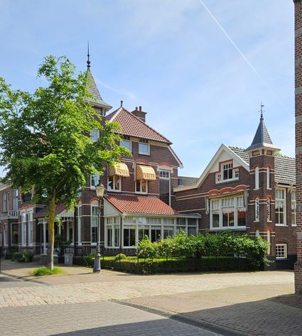
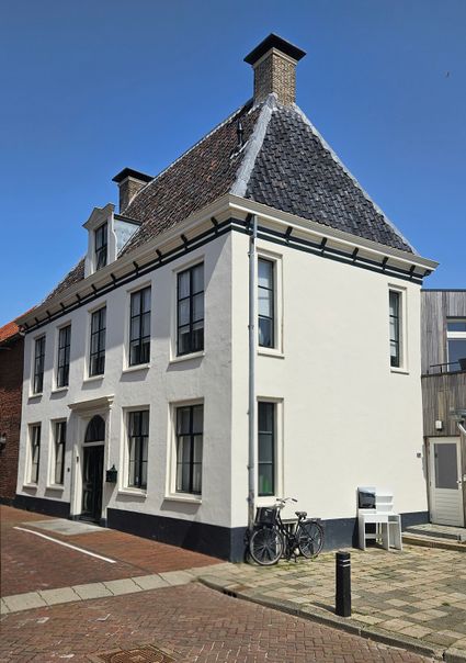
Villa Marie at Kasteel 6. This house and adjoining office were built by Gerson Levie and his wide Maria Norden. Levie was a grain merchant and the director of a cooperative grain-trading association. Local architect Johannus D. Meppelink designed this building in a style similar to the Jugendstil style. Cross the street. There is a castle on the opposite side of the street in front of you.
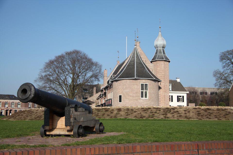
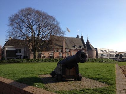
Before the construction of the fortress (around 1600), the castle was what gave Coevorden’s its strength. A 1395 agreement between the bishop of Utrecht and his allies decreed that Coevorden castle would be the only castle in Drenthe. This has stayed that way ever since. In 1796 the main building of the castle was sold to private parties. They used part of it as a warehouse and built residences inside of it. Next to the castle is the so-called Gouvernementshuis (“Governor’s House”). It served as the home and professional headquarters of the fortress’ governor—highest military commander—, and finally as a military hospital. From 1900 to 2008, it served as the town hall. Together with Het Gouvernementshuis and warehouse De Vlijt, the castle now functions as a catering establishment. Its façade still features one of the oldest reminders of Coevorden’s turbulent history: the coat of arms of Duke Karel van Gelre, placed here after the duke’s visit to Coevorden in 1527. From the castle, take a left onto the footbridge. Left lies Het Hof van Coevorden.
Het Hof van Coevorden is Coevorden’s new, multifunctional town hall. Architect Thomas Rau from Amsterdam developed this uniquely-shaped and sustainable building for a historic location between Coevorden’s castle and market square. Its location was at the centre of the Coevorden municipality’s high ambition “to build a monument for the future.” Walking from the walking bridge towards the town hall, mounted atop a natural stone base, you see...
The trio of sculptures, “De Drie Podagristen,” was offered to the municipalities on 9 May 1968 at the initiative of Professor Dr H.J. Prakke, for the occasion of the opening of the international touristic Dr Picard Route. The three podagristen (podagrist literally meaning “someone who suffers from gout of the foot”) were: Dubbeld Hemsing van der Scheer, Harm Boom and Alexander Lodewijk Lesturgeon. They are often referred to as the pioneers of Drenthe’s emancipation. Walk back to the castle and take a right back into the street. Cross the road and take a left. On the other side of the Aleida Kramersingel, you see the Aleida Kramer Hospital.
This hospital was originally founded in 1904 from the bequest of Miss Aleida Gerridina Kramer (1846-1902). A clever, slender woman accustomed to wearing a black dress and black shoes, Aleida led an honourable, albeit unremarkable life. She was highly frugal in her spending behaviour. In her will, this rich benefactor had decided that a large part of her capital should be used for the construction of a hospital. On the next street corner, you see the former...
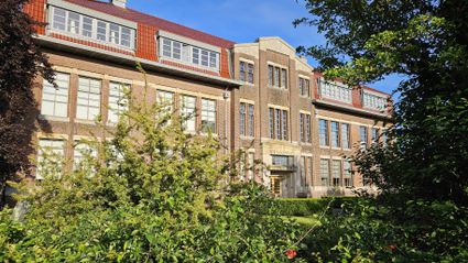
This vocational school, founded in 1919, only had the use of one rented classroom along Wilhelminasingel during the first few years of its existence. The construction of the new school was completed in 1924. Owing to its impressive exterior, the school was sometimes also referred to as Het Paleis van het Noorden (“Palace of the North”). The building is currently property of housing corporation Wooncom, which has created private residences and offices in it. The building was designed by Coevorden architect H. Bennink. Before reaching the vocational school, take a right onto Burgemeester Gautiersingel. At the end of the road, you arrive at Stieltjeskanaal. Cross the road by the bridge and take a left once you reach the other side. After 20 metres, take a right through the gate, into the Van Heutsz Park. Continue straight on the path past De Oranjebank. Continue the route. Where the three footpaths meet, on the left behind the conifers, you find...
The monument in memory of the breaking of Coevorden’s siege in 1672. On 30 December 1672, Coevorden, in the hands of the bishop of Munster (Bommen Berend) at the time, was recaptured by the troops of Carl van Rabenhaupt, the military commander of Groningen. The plan of attack for the spectacular recapture was created by teacher and verger Meyndert Minner van der Thijnen from Coevorden. He himself participated in the attack. As a reward, he was gifted a gilded silver cup. Later, he even became the city’s mayor. Continue along the city canal. On your left you find...
Also referred to as Het Noorse Huis (“Norse House”), the wooden villa in the Van Heutsz Park was built from wood on a stone plinth during the twenties of last century. The building was originally across the national border in Emlichheim, where it was built as the private residence of the director of the local strawboard factory. When relocating to Coevorden, the director took his house with him. Continue along the water. You end up on Dr. Picardtlaan. Left you see...
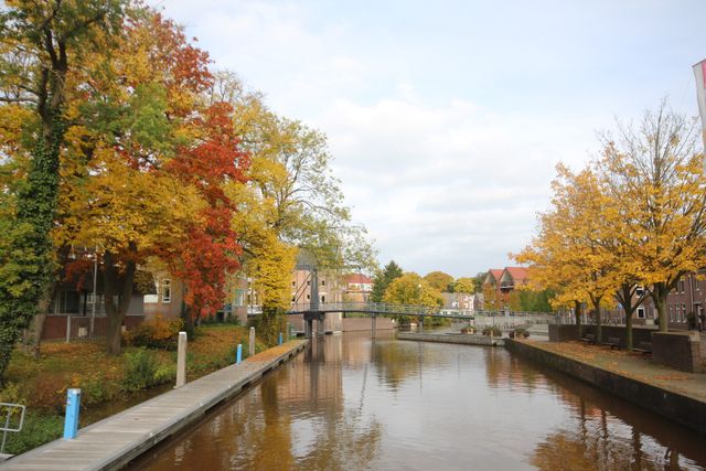
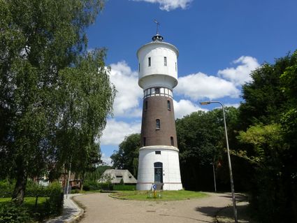
The water tower was built in 1914 and is a little over 32 metres tall. Coevorden experienced an economic upsurge in the period prior to the First World War. Among other things, a railway track, tram tracks, new factories, residential neighbourhoods and canals were built in this period. The water tower is part of the municipal water supply company. An extensive system of pipes running through the city provided the city and its new residential neighbourhoods with running water. This definitively ended the era of drinking from wells, canals and water holes. Take a right and then cross the road. Walk onto the canal pathway on the other side of the road. The moat used to be part of the city’s defences. This was the outer ring of canals. You have a beautiful view of the remains of the star-shaped canal from here. Walk all the way to Churchilllaan from here. On your right, you see...
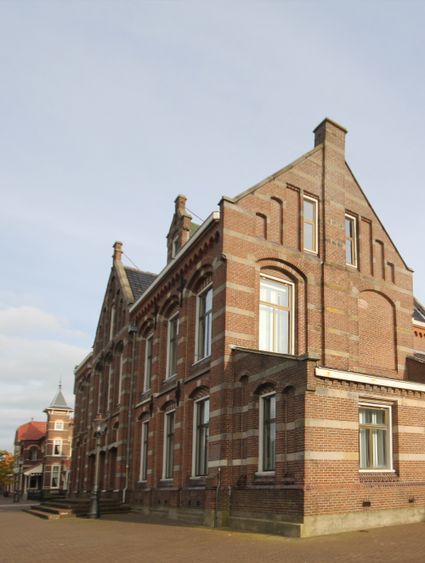
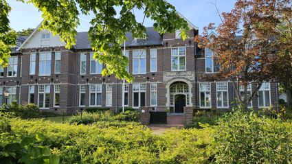
The Rijks Hogereburgerschool started in the school year of 1909-1910 in an empty school building along Wilhelminasingel. The new monumental building was designed by government architect Vrijman and went into use in 1910. The building was later taken over by housing association Domesta, which turned it into an apartment complex. Follow the Churchilllaan and take a right at the end past Van Heutszsingel. Use the zebra crossing to cross Van Heutszsingel and take a left. Subsequently, take the second right into Aleida Kramerstraat. On your right at number 9, halfway along this street, you see...
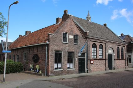
A laundry was housed in the Baptist church (Aleida Kramerstraat 9) around 1910. After its renovation in 1960, the building went into use as a church. Walk out of the street, take a right and follow Aleida Kramersingel. After 50 metres, on your left you see...
The (former) orphanage at Weeshuisstraat 26 was built in 1690 and was part of the diocese of the Dutch Reformed Church. An orphanage was an absolute must in a city home to many orphans and near-orphaned soldier’s children. An “orphan father” and “orphan mother” took on the care of the children and needy senior citizens. Over the years, the institute increasingly took on the function of a retirement home for elderly men and women. The farm next to it supplied the institute’s daily needs in terms of vegetables, fruit, meat and dairy. The inscription in the sandstone portal above the door in the simple, plastered façade reads: “Hij heeft gestroid, heeft den armen gegeven sin goedertirenheid gedurd in eeuwigheid.” (“He handed out and gave to the poor. His mercy will live on into eternity.”) Of the year 1690. In 1957 a new retirement home called De Schutse was opened in the neighbourhood of Poppenhare. This is when the diocese sold the old orphanage. Continue straight into Molenstraat (promenade). On your right, you see the former barracks complex.
The right side of Molenstraat once formed a long barracks complex with, on the corner of Molenstraat and Friesestraat, a stepped gable and a plaque from 1765. The officer’s residence used to be where Café Het Geveltje is now housed. In 1908, the tuitgevel (a soberer form of a stepped gable) was given a stepped gable ridge by the owner at the time. Diagonally across from Friesestraat is where the guardhouse of De Friesche Poort used to be located. The gate itself merely consisted of a closable passageway under the city walls. The barracks complex used to be several barracks longer, but these buildings were demolished several years ago to make way for a big road. Many soldiers and officer families inhabited this long row of houses until 1854, when the Coevorden fortress was definitively abandoned as a garrison location. Leaving Molenstraat, take a left into Friesestraat. After roughly 200 metres, you see a house with a unique façade on your right.
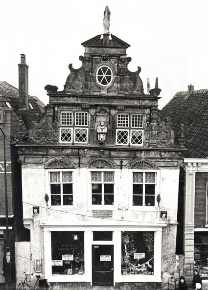
This house with its Renaissance-style façade at Friesestraat 9 deserves special attention, since it is one of the few façades of this type in the Netherlands. The colourfully-painted sandstone gable has been constructed in a rich, Flemish/North German Renaissance style. Originally constructed for a rich Roman Catholic sheet merchant, the house was used for retail for many generations. The bottom part of its façade dates from 1900. The former lower façade consisted of two windows with a stone platform in between them, elegant handrails on both sides and a door in the middle. The statue in the façade’s niche represents the daughter of the current owner. Dating back to 1631, the façade has texts written in the language spoken in the border region at the time, with, among other things, a prayer for the protection of the house and its inhabitants. These kinds of texts are common features in the façades of houses and farms on the German side of the border. Take the second right into Kerkstraat. On your right, you see the Dutch Reformed Church.
The current church building was completed in 1645. In 1641 (see the stone above the main entrance) the foundations were laid and the walls were constructed up to the height of the access gates. Financial restraints meant construction had to take place in phases. The church was built on land that had for centuries housed an older church. In 1592 the former Roman Catholic church was so badly damaged by acts of war that it could no longer be restored. The Reformed Church is one of the first new Protestant church buildings in the Netherlands. Instead of using a Latin cross, more common at the time, the church’s builders opted for a Greek Orthodox cross, the arms of which are of equal length. Other famous examples of Early Protestant church architecture are De Noorderkerk (“Northern Church”) in Amsterdam and De Nieuwe Kerk (“New Church”) in Groningen. The exterior is sober and the interior is sleek-lined and attractively-proportioned. Parts of the old church were used for its construction. The back gate still has a reference to the year 1612. In 1895 the spire was hit by lightning; the fire that followed burning the church so badly that it had to be demolished. In the fifties, the church was restored after damage sustained due to acts of war in April 1945. A final, more thorough restoration took place in 1982/1983. In addition to a number of special tombstones, the church has a memorial plaque to Dr Johan Picardt, preacher in Coevorden, and Drenthe’s first historian. He was born in the year 1600 in Bentheim and died in Coevorden in 1670. Picardt studied philosophy, medicine and theology. He had a considerable impact on the peat reclamations in the German county of Bentheim. The small municipality of Alte Picardie near Neuenhaus has been named after him. The church also houses a memorial stone for verger/teacher Meyndert van der Thijnen (see number 9), who was given a “remembrance for his children” in the shape of a gilded silver cup worth a hundred guilders from the Council of State for his cunningness and bravery in the liberation of Coevorden in 1672. Like his assistant Claes Buyter, whose alias was Guldenhoedt (“guilded hat”) and who also received a cup, he donated this cup to the Reformed community. After first working as a milliner, Claes Buyter later became a soldier of Coevorden’s Drentse Compagnie (“Drenthe Company”). Both cups were used as Holy Communion cups for three hundred years. Today, they can be observed in the Stedelijk Museum. There is another memorial stone in honour of Carl von Rabenhaupt (Bohemia 1602 - Coevorden 1675), baron of Sucha and Drost of Coevorden from 1673 to 1675 (a drost was a high-ranking local official position). He was given this title as a reward for his actions during the fighting of 1672. His body was buried under a funerary monument in the church after his passing. This monument was removed by patriots in 1795. A copy of the helmet that crowned the mausoleum can be found in the Stedelijk Museum. The original can be viewed at the Drents Museum in Assen. Originally from the garrison church of Lehrort (Germany), which was abolished in 1745, the copper baptismal font was gifted to the church of Coevorden by the Council of State. Also functioning as a concert organ, an exquisite church organ was placed here in 1973 as the successor of an organ gifted to the church by Aleida Kramer in 1897. The beautifully-carved oak pulpit dates back to 1647. The sounding board is decorated with a wooden sculpture that represents the symbolic connection between heaven and earth: the crescent and the earth, and the bunch of grapes connected by the Holy Communion cup. In the building you also see two stained glass windows, which were designed by Groningen’s famous painter and member of artistic company De Ploeg, Johan Dijkstra. In 1977 the carillon, a gift from the former Burgerzin Foundation, was installed in the tower. Continue straight into Kerkstraat.
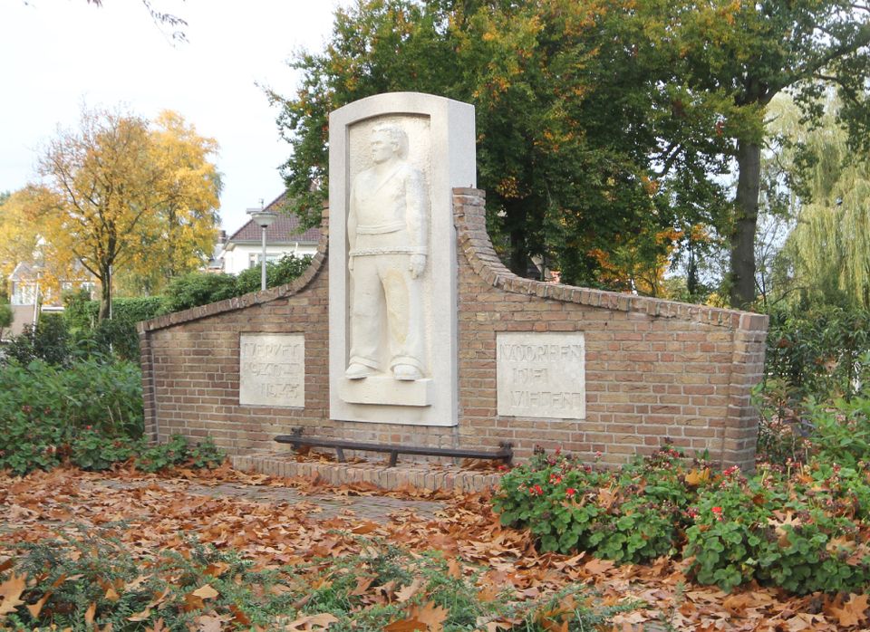
To the right of the road, at Kerkstraat 36, lies the synagogue. In 1768 the Jewish community turned to Drost Alexander R.R., Count of Heiden (1748-1776), asking for permission to build a synagogue with a cemetery behind it. Permission was granted on 17 May 1768. The number of Jewish inhabitants at the time was 76. In 1840 the building was entirely renovated, and a house for the synagogue’s religious teacher was built alongside it. In 1930 there were 340 Jewish citizens in Coevorden, but shortly before the Second World War, their numbers had decreased to around 200 people. In the night of 2 to 3 October 1942, all Jewish inhabitants were transported to Camp Westerbork. Of those transported, only 14 returned after the war. Like the rabbi’s house, the totally neglected synagogue was restored in 1975 and 1976, and the cemetery was cleared (the bones from the cemetery were reburied at the Jewish cemetery on Ballastweg). In 1985 a monument designed by Coevorden artist Wouter van Rossum was installed by the side wall of the former rabbi’s house in memory of the town’s Jewish inhabitants who didn’t return after the war. The sculpture symbolises the hole their loss created in the hearts of Coevorden’s citizenry. After its renovation, the building was used as the regional music school. This school is now housed in the Hof van Coevorden. Turn around and walk back towards Markt.
The white-plastered residential home at Kerkstraat 1 began to be used as the town hall by the mayor of Coevorden at some point during the 17th century (around 1673). Before that time, owing to financial constraints, the magistrate had rented accommodation in an inn. The building was used as a town hall until 8 November 1900, when the Governor’s House was purchased and used as such. In December 1770, the famous IJzerkoeken Revolt (ijzerkoeken are a type of traditional Dutch biscuit), a popular movement that arose as a result of widespread dissatisfaction with the government, took place in front of this town hall. Ecclesiastical authorities and the city council had forbidden citizens from making their traditional rounds—characteristically accompanied by the consumption of large quantities of alcoholic beverages—through the city on New Year’s Eve. The restriction didn’t go down at all well with the citizenry, resulting in a march of waffle-iron-wielding women on the town hall. The magistrates were chased down by the angry mob of women, their coat tails pinched squeezed between the waffle irons. The current building was modernised in 1817 and remained in use by the city council until 1900. At the end of Kerkstraat, you arrive at Markt.
Opposite Kerkstraat is the small statue of so-called goose guardian Ganzen Geesje. Standing on a base of artificial stone, this bronze statue is an ode to the geese guardians who, until the start of the previous century, would take their geese to the traditional goose market on the second Monday of November. Here, the animals were sold to traders who, especially after the arrival of the railway train in 1905, had many geese transported to England to serve as Christmas meals. Towards the end of the 19th century, traders were increasingly buying from farmers at home. Better water management in the region also contributed to the demise of goose keeping in the twenties. The swamp lands and the many ponds that had been used for goose keeping became farmlands and pastures. The election of Miss Ganzenhoedster (“Miss Goose Guardian”) has been a returning feature of the goose market since 1962. The official unveiling of the statue took place on 14 October 1978 with Drenthe’s Queen’s Commissioner, Mrs A.P. Schilthuis, doing the honours. Artist: J. Sterenberg from Makkum. Take a right at Markt into Bentheimerstraat. Bentheimerstraat is a shopping street in which many retailers live and work, and have lived and worked in the past. Aptly-named, it is the street heading towards the county of Bentheim. At the end of the street, in front of the fortress’ inner canal, is where the Bentheimerpoort (“Bentheimer Gate”), one of the two entrances to the city, used to be. At number 48, on the right corner of Spoorhavenstraat, we observe the remnants of a barracks building with its original tuitgevel (a kind of pointed gable) from 1770. As in Friesestraat, the barracks was located right behind the gate. The barracks were strategically positioned at the end of streets that all radially ended at Markt. We continue walking until we reach Bentheimerbrug (“Bentheimer Bridge”), which goes across the old moat. Before reaching Bentheimer Bridge, take a left. Take the pathway alongside the water. This remaining part of the inner moat forms the connection between the Coevorden-Almelo canal and the Stieltjes canal—two very important waterways in South East Drenthe. The Coevorden-Alte Picardie canal also discharged in the moat. Urban developments are in full swing in this region. Archaeological digs have led to some surprising finds here.
In the curve by the water’s edge, you arrive at the modern interpretation of a bastion. In the 17th century, seven bastions protected the city of Coevorden against its enemies. These bastions were protruding defensive structures, and part of the fortress. Canons stood on top of them. Separated from the enemy by water and high walls, Coevorden’s seven bastions were at the edge of the city. All of bastions were stripped when the fortress was dismantled in 1854. To make the structure of the fortress visible again, three of the seven bastions have been rebuilt in a modern style. Continue walking alongside the water until you reach the next bridge. Take a left via Oosterstraat towards Markt. With this you’ve come to the end of the ToReCo Fortress Walk.