Ten Villages

3 hour 21 minutes (67.0 km)

  • Download
  • Hop on your bike in Hoogeveen and discover the traces of the area’s rich peat settlement history. Follow the signposted route through the following ten villages: Fluitenberg, Pesse, Stuifzand, Tiendeveen, Nieuweroord, Noordscheschut, Hollandscheveld, Nieuwlande, Elim and Nieuw Moscou.

    Hoogeveen was founded by Roelof van Echten. He bought…

    Hop on your bike in Hoogeveen and discover the traces of the area’s rich peat settlement history. Follow the signposted route through the following ten villages: Fluitenberg, Pesse, Stuifzand, Tiendeveen, Nieuweroord, Noordscheschut, Hollandscheveld, Nieuwlande, Elim and Nieuw Moscou.

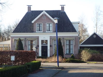
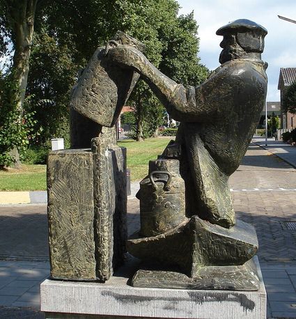
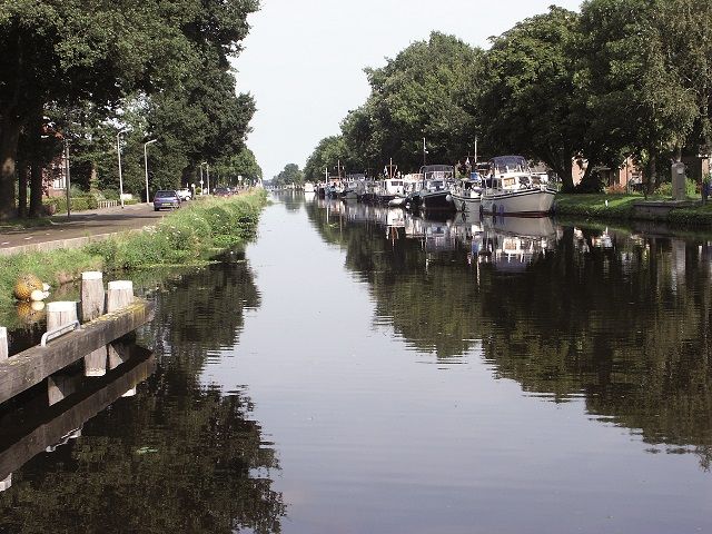
    Hoogeveen was founded by Roelof van Echten. He bought a large area of peatland in the Zuidwolde region in 1625. To reclaim the land, he founded the Compagnie van de 5000 Morgen (“the Company of the 5000 Tomorrows”). To provide access to the area, the company dug a canal with lateral canals. This is where the roots of Hoogeveen lie. Work of art “De Cascade” in the commercial centre of Hoogeveen (Hoofdstraat) was constructed in memory of the canal.

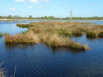
    After Fluitenberg and Pesse, you pass through the stream valley of Oude Diep with its majestic panoramic views. To the east of Hoogeveen, the rectangular landscape of the former peat settlements comes into view. This is where reclamation works started in the 17th century. Dead plant matter—formed over hundreds of years—had formed a layer of peat several metres thick in the swampy peatlands. After being removed and dried, the peat was called turf and was used as a fuel. To assist in the peat’s excavation, housing estates and waterways were constructed. This is where the settlements of peatland labourers arose—later developing into the villages we see today.

    The route starts at Crerarstraat in Hoogeveen. There is free parking at the Nederlandse Spoorwegen (NS) railway station. You can also use the signposting present to start the route from other locations.

    Sights on this route

    Starting point: Crerarstraat
    7901 AA Hoogeveen
    31
    34
    08
    09
    20
    1

    2

    39
    36
    23
    24
    38
    3

    37
    4

    16
    5

    6

    14
    7

    50
    51
    52
    8

    9

    19
    91
    15
    13
    12
    35
    33
    End point: Crerarstraat
    7901 AA Hoogeveen

    Directions

    Starting point: Crerarstraat
    7901 AA Hoogeveen
    • The first village that you cycle to, and most likely inhabited for a long time, is Fluitenberg. Its long history of human habitation is made clear by seven prehistoric burial mounds have been found in the area. The village has been constructed on a hill of grit that arose during the last ice age. Located along the small river De Vleute, which is called Oude Diep today, the village was previously called Vleutenberg.
    • Cycling in a northerly direction, you arrive in Pesse. A real Drenthe esdorp (a type of village in the Netherlands, often originating in medieval times, bordering on an area of sandy soils), this village was already known as Petthe as far back as 1141. The name originates from Peltha, an old word for swampland. When the A28 motorway was being constructed in 1955, a hollowed-out tree trunk was found in the median strip near Pesse. A unique find, which was later discovered to be the world’s oldest boat. Carbon dating revealed that this tree trunk canoe dates back to between 8200 and 7600 BC. The canoe was preserved this long because it had sunk into a riverbed in peaty soil. It can be visited at the Drents Museum in Assen.
    • Leaving Pesse behind, you quickly find yourself passing through Boerenveensche Plassen nature reserve. This nature reserve consists of extensive heathlands and contains large bodies of water and peatland. It is an area that is continuously changing. The area alternates between being soggy and bone dry. Next, you cycle through the stream valley of Oude Diep with its beautiful views, crossing Oude Diep afterwards. See how the winding stream finds its way from the higher-lying grounds of the province of Drenthe’s centre towards the province’s edge.
    • Stuifzand is the next village. The name Stuifzand, meaning drifting sand, points towards the area’s sand-filled history. The first sand and heathland reclamations started here in the 18th century; the first inhabitants started settling here in 1850.
    • Moving towards Tiendeveen, the rectangular parcelling of the landscape reveals the region’s past as a peat settlement. Tiendeveen is an expansive peat village that arose along the intersection between canals Linthorst Homankanaal and Drijberse Hoofdvaart. Excavations of the peatland started here in 1830, which is also when the first inhabitants started settling in the area. After the peatland had been excavated, forests were planted on the reclaimed land. Several of these forests still remain—among them, the forest Kremboong. Today’s Tiendeveen roughly originated in 1926.
    • Time to put the pedal to the metal until we arrive in Nieuweroord. In 1849 a few gentlemen from Amsterdam and Utrecht purchased Westerborker Broekvenen and Mekelermeersche Veen—together comprising around 1,400 hectares of land. They founded the Maatschappij tot Exploitatie der Westerborker Broekvenen (“Company for the Exploitation of Westerborker Broekvenen”). They had a house built here that was called Nieuweroord and in which one of the investors resided: Jan Coenraad Rahder, an Amsterdam-based wine merchant. The village of Nieuweroord arose around this house. The house was demolished in 1919.
    • A little further lies the village of Noordscheschut. The village is intersected by the canal Verlengde Hoogeveensche Vaart en is named after a lock that was built between canals Noordsche Opgaande and Hoogeveensche Vaart in 1766. Noordscheschut exists thanks to the peat excavation activities of excavator Jan Coenraad Rahder during the middle of last century. His family later moved into the house by the lock: Huize Blokland (“Blokland Manor”). This house from 1861 is still standing. You can become acquainted with the history of the village at the story pole that is on your immediate right after crossing the lock.
    • Cycling in a southerly direction, you arrive at the largest village of the route: Hollandscheveld. Take a well-deserved break at one of the local catering establishments. This village owes its name to the rich Hollanders who started reclaiming the peatland in the area in the 17th century. In the sixties of last century, national celebrity Hendrik Koekoek made Hollandscheveld his home, generating national fame for the village. He was the leader of De Boerenpartij (“the Farmers’ Party”), which was undergoing a period of rapid growth in the Netherlands’ Lower House of Parliament (Tweede Kamer) at the time. Its growth was primarily a result of the so-called farmers’ revolt in Hollandscheveld in 1963. Another story pole can be found at the ‘t Hoekje-Zuideropgaande intersection. Opposite the story pole, you find the Reformed church, a Neoclassical aisleless church with an 1851 façade steeple.
    • Between Hollandscheveld and Nieuwlande, you cycle past recreation area Schoonhoven. Take a break here for an ice cream and a paddle, or sit by the water’s edge on the beach. Forests, now among the oldest in Drenthe, were planted on the reclaimed lands here at the start of the 19th century.
    • It’s time now to get back on the bike and head towards Nieuwlande. Nieuwlande arose towards the end of the 19th century following reclamations along an intersection of canals. The village is famous for the fact that it hid many fugitives during the Second World War. Johannes Post was the driving force behind organised resistance here. Nieuwlande is one of only two villages in Europe to have received a Yad Vashem honorific from Israel in recognition of the assistance it gave to people in hiding during the Second World War. The monument that holds the certificate consists of a brick wall with an arched centre, and can be found on Brugstraat. Next to this monument is the resistance monument. Museum De Duikelaar has, among other things, Jo Schonewille’s private collection on display. Opposite Johannes Post’s former farm at number 17, in the forest by Johannes Poortstraat, you can find the hideout that the fugitives used.
    • Enjoy the views of the area’s expansive estates en route to Elim. Elim was given its current name in 1915. Its name originates from the Old Testament. Elim was the oasis where the Israelites stayed after their passage through the Red Sea. Its brink (a central open space to be found in many of Drenthe’s sandy settlements) has a statue of De Pullevaarder. Every day, he would pick up the milk churns from the farmers and transport them to the dairy factory in Hoogeveen. Every first Thursday of the month, on pulledag (“churn day”) farmers would go to the factory to pick up their money. Afterwards, they would head to Hoogeveen to purchase goods. Keeping with tradition, on Thursdays during the summer months, Hoogeveen’s centre still organises so-called churn days. These market days feature a host of different activities.
    • The last and most remote village is now coming into view: Nieuw Moscou. This village arose in the 19th century. It was jokingly named after the Russian capital city due to its remoteness.
    • Finally, a long cycle ride takes us back to Hoogeveen, where we can bathe in the afterglow of this special cycling route on one of Hoogeveen’s many terraces.
    End point: Crerarstraat
    7901 AA Hoogeveen
    • 31
    • 34
    • 08
    • 09
    • 20
    • 39
    • 36
    • 23
    • 24
    • 38
    • 37
    • 16
    • 14
    • 50
    • 51
    • 52
    • 19
    • 91
    • 15
    • 13
    • 12
    • 35
    • 33